
 |
| Cape Leveque at sunset |
The final leg of our 12 day West Kimberly tour was spent at Cape Leveque on the northern point of the Dampier Peninsula. Cape Leveque is 200km north of Broome via Cape Leveque Road. The northern half of Cape Leveque Road is unpaved, allowing this area to remain untouched and available only to those willing and able to make the trip.
Since we were coming from Windjana Gorge to the east and not from Broome to west, we opted for the 160km off-road track through the Dampier Peninsula which originates outside Willare and ends near Beagle Bay 80kms south of Cape Leveque - saving us a trip back to Broome. The trade-off to the shorter driving distance was a busted tire about 50kms short of Beagle Bay. Thanks to a spare tire and a handy husband we weren’t as unfortunate as the decomposing abandoned cars we passed along the way.
The Dampier Peninsula, known as Ardi “heading north” to the native people, is home to a handful of small aboriginal communities – some of which face seclusion during the rainy season when roads are flooded. We stayed at aboriginal owned Kooljaman Camp. Kooljaman offers a range of accommodation from camping sites to palm fringed beach huts and cabins. Aside from a restaurant and some basic provisions, life at Kooljaman and Cape Leveque is self-sustainable. When we required emergency supplies, we went to the aboriginal community at One Arm Point, 15kms from Cape Leveque, and visited the community’s one-stop-shop. Also in One Arm Point is Australia’s only Trochus hatchery.
The majority of our three days in Cape Leveque was spent fishing. We caught Spanish Mackerel, Northwest Snapper, Fingermark Perch and Mangrove Jack and watched dozens of Humpback Whales make their way through the area…never a camera in hand when they surfaced of course.
The dramatic change of the tide in this area is an awesome display of the magic of the ocean. Within hours a turquoise sea would become a bed of exposed rocks and a beach as big as a football field with the ocean’s precious treasures revealed.
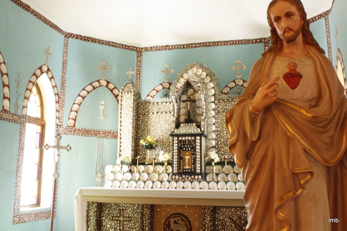
But one of the best parts of the Dampier Peninsula was not created by nature but by man. In 1890 Trappist Monks from France came to the Dampier Peninsula as missionaries. Ten years later, the remote lifestyle got the best of them and they departed and were replaced by the Pallottine Missionaries from Germany. The Pallottine Missionaries stayed there for another 90 years and in 1907 the Sisters of St. John of God from Ireland joined them.
While under house arrest in 1915 during World War I, the German priests and brothers and the local people began building Sacred Heart Church. Taking two years to build, Sacred Heart was molded after a photo of a German country parish - but couldn’t be further from one. Much of the detail of the church, including the alter, is made from mother of pearl, cowries, volutes and olive shells – paying tribute to the surrounding beauty of the land and heritage of the local people.
Other popular Dampier Peninsula activities include mud crabbing, aboriginal tours and helicopter rides.
 |
| Dampier Peninsula |
 |
| Cape Leveque |
 |
| low tide, Cape Leveque |
 |
| Cape Leveque |
 |
| Sacred Heart Church, Beagle Bay |
 |
| Sacred Heart Church, Beagle Bay |
 |
| Sacred Heart Church, Beagle Bay |
 |
| Sacred Heart Church, Beagle Bay |